An overgrown mound, measuring 15m by 19m and probably originally sub-circular in shape, lies on the coast edge and is eroding. It extends to the rear into the adjacent pasture field. On the seaward side, stone is revealed in numerous small exposures in association with anthropogenic soils containing peatash. These deposits sit over a bedrock outcrop which stands to 3m above the level of the beach. Previous surveys recorded fragments of bone in the section and have tentatively linked these remains with a chapel site alleged to lie in the area (located at HY6534 4133). Ref.: RCAHMS (1946), #178; RCAHMS (1980), #170.
Location
365360.00
1041360.00
27700
59.2573509
-2.6092129
Submitted photographs
Image
Date
Caption
User
09/12/2014
Flint recovered from section
John
09/12/2014
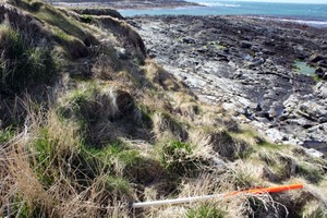
Seaward side of mound showing vegetation and hint of a stone structure, looking West
training1
09/12/2014
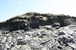
Mound on bedrock outcrop, looking South
training1
Submitted updates
Update id
Date
User
1882
09/12/2014
training1
Tidal state
Mid
Site located?
Yes
Proximity to coast edge
Coast edge
Coastally eroding?
has eroded in the past
Visibility above ground
Not visible
Visibility in section
Limited visibility in section
Access
accessible - difficult terrain
Description
ShoreUPDATE 24/04/2013
As described except more vegetated and very limited exposures visible in 2013.
Access across the mound to look at the seaward side of it is very difficult.
ShoreUPDATE August 2015
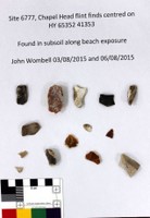
Fourteen struck flints recovered from subsoil in the vicinity of the eroding section. Most are chunks and chips, some probable broken cores. One broken flake.
Stable in 2013. It would be very difficult to do any recording of the seaward side of the mound due to difficulty of access and dangerous location. There is nowhere to stand to take photographs or make a drawn record. Use of a drone would be appropriate here.
Re-assign priority 3 - occasional monitoring only.