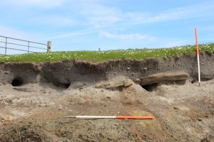
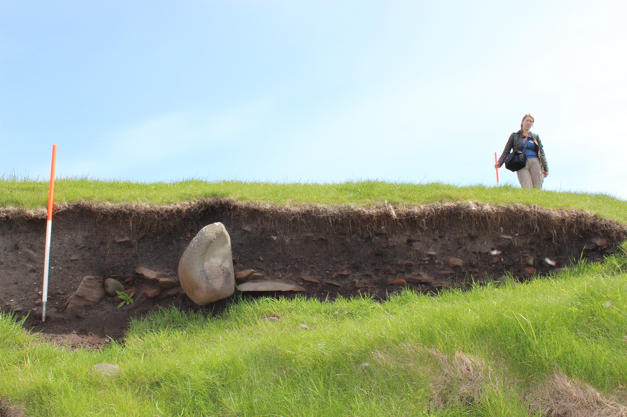
A series of consecutive coastal exposures reveal anthropogenic deposits and structural remains which indicate prehistoric settlement. The site is low-lying and in a relatively sheltered position, close to a sandy beach. At least one structure can be inferred from the remains. This had walls built, at least partly, of stone and a paved floor. The use of orthostatic and edge-set stones in the walls is indicative of a prehistoric date. This is further suggested by the types of artefacts which occur within the exposed deposits. To either side of the structure there are deep soils which appear to have been cultivated. The exposures occur over an 85m long stretch of coastline and are described below, moving from S to N: (i) Cultivation soils, up to 0.9m deep, are exposed in an 8m long coastal section. (ii) One large upright stone and a row of edge-set stones are exposed in a 5m long section. The stones form part of a wall which projects from the section at an oblique angle. The section also contains deposits of shattered stone and cultivation soils which are up to 1m deep. (iii) Fragments of stone paving and walling are exposed over a distance of 8m in a section which stands 0.8m high. The paving is laid over till and covered by anthropogenic soils which contain frequent inclusions of shell, some burnt stone and one fragment of a trough quern. (iv) In a 2m long section which stands 0.6m high there are stony deposits which may represent structural remains. A rough stone tool was noted among the mass of stone. Further structural stone lies ex-situ, on the foreshore in front of this exposure. (v) Cultivation soils and structural remains are exposed in a 7m long section which stands 1m high. The structural remains comprise two orthostats and some associated rubble. The soils contain frequent inclusions of bone, shell and charcoal. Several rough stone tools were noted within these deposits. (vi) Cultivation soils, up to 0.8m deep, are exposed for over 20m. There are frequent inclusions of shell and a stone tool was also noted.
28/05/14
More or less as described but difficult to identify exactly individual numbered features. Some elements described may be natural but there is definite evidence of structures and anthropogenic soils.
Erosion on this low lying rocky coast edge is occurring at a slow rate and having a limited impact upon archaeological deposits.
Location
442510.00
1122680.00
27700
59.9868088
-1.2399771
Submitted photographs
Image
Date
Caption
User
28/05/2014
General view showing thick cultivation soils
training1
28/05/2014
Horizontally laid stone
training1
28/05/2014
Walling, looking east
training1
28/05/2014
Edge set stone, possible structure
training1
Submitted updates
Update id
Date
User
1660
28/05/2014
training1
Tidal state
High
Site located?
Yes
Proximity to coast edge
Coast edge
Coastally eroding?
has eroded in the past
Visibility above ground
Not visible
Visibility in section
Limited visibility in section
Access
accessible on foot (no footpath)
Local knowledge
don't know
Description
A series of consecutive coastal exposures reveal anthropogenic deposits and structural remains which indicate prehistoric settlement. The site is low-lying and in a relatively sheltered position, close to a sandy beach. At least one structure can be inferred from the remains. This had walls built, at least partly, of stone and a paved floor. The use of orthostatic and edge-set stones in the walls is indicative of a prehistoric date. This is further suggested by the types of artefacts which occur within the exposed deposits. To either side of the structure there are deep soils which appear to have been cultivated. The exposures occur over an 85m long stretch of coastline and are described below, moving from S to N: (i) Cultivation soils, up to 0.9m deep, are exposed in an 8m long coastal section. (ii) One large upright stone and a row of edge-set stones are exposed in a 5m long section. The stones form part of a wall which projects from the section at an oblique angle. The section also contains deposits of shattered stone and cultivation soils which are up to 1m deep. (iii) Fragments of stone paving and walling are exposed over a distance of 8m in a section which stands 0.8m high. The paving is laid over till and covered by anthropogenic soils which contain frequent inclusions of shell, some burnt stone and one fragment of a trough quern. (iv) In a 2m long section which stands 0.6m high there are stony deposits which may represent structural remains. A rough stone tool was noted among the mass of stone. Further structural stone lies ex-situ, on the foreshore in front of this exposure. (v) Cultivation soils and structural remains are exposed in a 7m long section which stands 1m high. The structural remains comprise two orthostats and some associated rubble. The soils contain frequent inclusions of bone, shell and charcoal. Several rough stone tools were noted within these deposits. (vi) Cultivation soils, up to 0.8m deep, are exposed for over 20m. There are frequent inclusions of shell and a stone tool was also noted.
28/05/14
More or less as described but difficult to identify exactly individual numbered features. Some elements described may be natural but there is definite evidence of structures and anthropogenic soils.
Erosion on this low lying rocky coast edge is occurring at a slow rate and having a limited impact upon archaeological deposits.