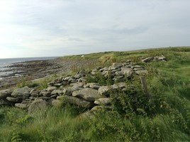
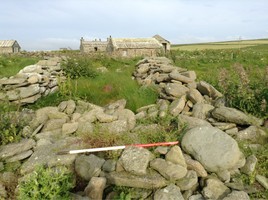
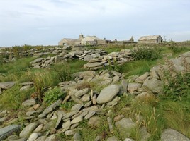
(i) A series of up to seven conjoined boat sheds or noosts are represented by ruinous, roughly-built rubble and beach stone walls. They are rectangular in shape, measuring up to 5m in length by 3m in width; the walls stand up to 0.75m high. The bases or floors of these structures are roughly paved. (ii) In this area there are frequent lengths of drystone walling which previously served to dry kelp upon. They measure up to 10m long by 1m wide and are constructed from a range of materials including beach stone, rubble, cast concrete supports, wood, metal and disused barrels. Most are aligned at 90o to the coast edge and some have been completely covered up by blown sand deposits and grass. (iii) There are also frequent kelp-burning pits and roughly cobbled surfaces for kelp-working along this stretch of coastline. The majority of the pits are partially filled in, but in some cases a stone lining remains visible. (iv) Underlying the more recent remains of kelp processing, see (ii) and (iii) above, there are faint indications of old boundary walls or banks which have been entirely covered over with blown sand. These appear to define a series of small rectangular fields.
05/07/14
Noosts as described. Plentiful evidence of kelp industry in the form of numerous regularly spaced tangle dykes, mounds of stone and pits along this whole stretch of coast. All remains behind substantial storm beach.
Location
344418.00
1050369.00
27700
59.3360023
-2.9787309
Submitted photographs
Image
Date
Caption
User
06/07/2014
3. Relationship of noosts to coast edge and storm beach.
training1
06/07/2014
2. Detail of a typical noost, looking east.
training1
06/07/2014
1. General view of noosts, looking northeast
training1
Submitted updates
Update id
Date
User
1723
06/07/2014
training1
Tidal state
Mid
Site located?
Yes
Proximity to coast edge
< 10m
Coastally eroding?
not eroding; accreting
Visibility above ground
Highly visible (substantial remains)
Access
accessible on foot (no footpath)
Local knowledge
has local associations/history
Description
(i) A series of up to seven conjoined boat sheds or noosts are represented by ruinous, roughly-built rubble and beach stone walls. They are rectangular in shape, measuring up to 5m in length by 3m in width; the walls stand up to 0.75m high. The bases or floors of these structures are roughly paved. (ii) In this area there are frequent lengths of drystone walling which previously served to dry kelp upon. They measure up to 10m long by 1m wide and are constructed from a range of materials including beach stone, rubble, cast concrete supports, wood, metal and disused barrels. Most are aligned at 90o to the coast edge and some have been completely covered up by blown sand deposits and grass. (iii) There are also frequent kelp-burning pits and roughly cobbled surfaces for kelp-working along this stretch of coastline. The majority of the pits are partially filled in, but in some cases a stone lining remains visible. (iv) Underlying the more recent remains of kelp processing, see (ii) and (iii) above, there are faint indications of old boundary walls or banks which have been entirely covered over with blown sand. These appear to define a series of small rectangular fields.
05/07/14
Noosts as described. Plentiful evidence of kelp industry in the form of numerous regularly spaced tangle dykes, mounds of stone and pits along this whole stretch of coast. All remains behind substantial storm beach.
Interesting and well preserved sites as examples of coast specific activity. Located behind storm beach. Not under serious threat of erosion.