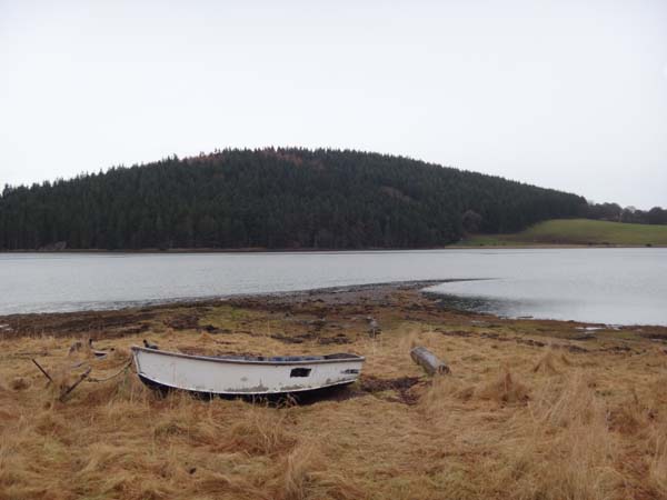
Trackway and jetty remaining, but no upstanding mill.
13.2.13 - Was there a mill? Nothing visible at all at the site. Nor is there now any superstructure that could be interpreted as a jetty.
At the site, there is a shingle and shell spit curving into Munlochy Bay, a moored boat, and a partially overgrown track that leads up the south bank by the east side of a field.
The south bank probably represents a raised beach.
The track would suggest that the "jetty" as was may have been used as a ferry point across the bay. The site represents the most northerly point of the south shore of Munlochy Bay.
Location
266591.00
852960.00
27700
57.5470123
-4.2307434
Submitted photographs
Image
Date
Caption
User
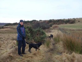
13/02/2013
Track leading from former "Jetty", looking SE
rolandsj
13/02/2013
Position of former Jetty, looking North
rolandsj
Submitted updates
Update id
Date
User
767
13/02/2013
rolandsj
Tidal state
High
Site located?
Yes
Proximity to coast edge
Coast edge
Coastally eroding?
accreting
Visibility above ground
Not visible
Access
easily accessible - no restrictions
Local knowledge
is not locally known
Description
Trackway and jetty remaining, but no upstanding mill.
13.2.13 - Was there a mill? Nothing visible at all at the site. Nor is there now any superstructure that could be interpreted as a jetty.
At the site, there is a shingle and shell spit curving into Munlochy Bay, a moored boat, and a partially overgrown track that leads up the south bank by the east side of a field.
The south bank probably represents a raised beach.
13.2.13 If ever there was a jetty or a mill, both have now gone. There is nothing to preserve.
Comments
The track would suggest that the "jetty" as was may have been used as a ferry point across the bay. The site represents the most northerly point of the south shore of Munlochy Bay.