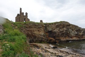
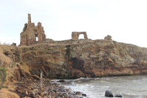
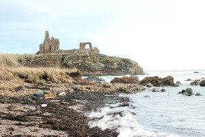
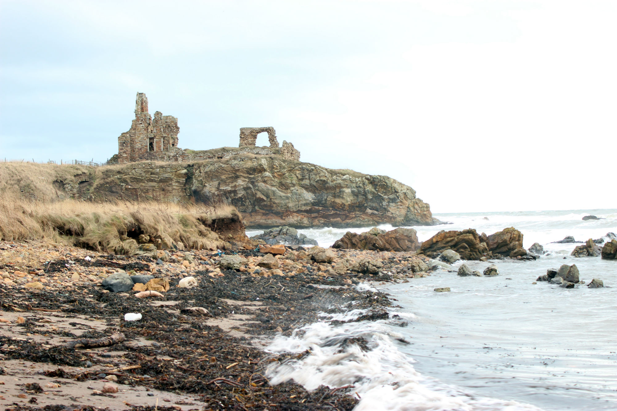
The remains of Newark Castle stand on a small promontory running into the sea. The main buildings stand on the summit of the promontory to the E with remains of an enclosing wall to the S and on the W along the cliff.
The earliest work is in the three most southerly vaulted cellars of the E range. These have been altered and give no indication of date. In the second period, early 16th century, the block was extended N and terminated at the NE angle in a circular tower, with an entrance gate facing N in its W side. In the third period, late 16th century, a new house was built on the second period ground floor, extending from the cellars to the wall of the tower and having a stair tower towards the courtyard. Late in the 16th century, the cellarage was altered and buildings at the S end of the courtyard, as well as those on the lower level, erected. In the fourth period, later 17th century, a storey was added to the 16th c house, and an upper storey to the tower. The courtyard was divided by a cross wall running N along the W cliff to meet the main outer wall. Other buildings, now represented by fragments of vaulted cellars, lay at a lower level towards the NW, access between the two parts being maintained by a newel stair, still traceable. At the lower level there was probably a water gate. RCAHMS 1933, visited 1927.
Generally as described and planned, although the N tower has partially collapsed and the walling on the W has been eroded by the sea. Visited by OS (DWR) 30 May 1974.
NO 518 012 Newark Castle sits on a promontory on the N side of the Firth of Forth, 1km W of St Monans. It probably dates from the 15th century and originally comprised ranges of buildings set around a courtyard. In the 16th century, the E range was extended northwards and a circular tower built onto it. Later that century, the upper parts of the N end of the E range and the tower were rebuilt and some of the ground-floor chambers altered, the northernmost one becoming a kitchen. In the late 17th century, the 16th-century house was heightened and Dutch gables added to it. Some parts of the castle were still occupied well into the 19th century when the tower walls were cut back to provide additional living space. This action contributed to the collapse of the N wall of the tower early in the 20th century, whilst coastal erosion has resulted in the loss of other buildings, including the entire W side of the castle. An archaeological evaluation was undertaken in advance of a proposed programme of restoration of the N end of the E range and its round tower. The principal areas of excavation were: the interior of the round tower and its entrance passage; the kitchen and its fireplace; the first-floor hall; and four trenches against the castle walls.
The tower. The remains of the tower stood five storeys above ground level, although excavation also uncovered a hitherto unsuspected basement. The tower measured 7.5m in diameter over walls 2.2m thick at their base, but reduced over most of the building's height. Piercing the E and W walls of the basement were embrasures terminating in circular gun-loops which had probably opened onto a ditch. At some stage the ditch had been backfilled with at least 5m of rubble and soil. The basement floor was bedrock, into which a square feature had been cut - perhaps a well - which was not excavated. From ground level upwards, the tower walls have been reduced and alterations made to many of the mural features, such as windows and gun-loops.
The kitchen. The kitchen was formed when a large fireplace was inserted into the end of the northernmost undercroft of the E range. Most of the floor of this chamber comprised bedrock although some crude paving had been added where there were undulations in the rock. Cutting the bedrock was a narrow channel leading to a slop drain, set below a window in the E wall.
First-floor hall. This room, probably a hall during the later phases of occupation, lay directly over the kitchen and measured 6.2m N-S by 5m wide internally. Turf and debris overlay a deposit of sand, presumably the setting for floor tiles or flags, although no trace of either remained. There were two fireplaces in the hall, one directly over the kitchen fireplace, and another much smaller one in the S wall.
Trenches outside the castle. Four trenches were excavated against the castle walls, primarily to determine the depths of their foundations. This objective proved difficult to achieve for several reasons, although some interesting features were nevertheless uncovered. Trenches were opened against the two main doorways into the E range, one of which gave access to the passage leading to the tower, the other to the kitchen and a turnpike stair (now demolished) which led to the first-floor hall. In both trenches, large sandstone flags were overlain by a secondary surface of hard-packed gravel. In a trench outside the E range a relieving arch was uncovered near the base of the E wall, over 2m below present ground level. Also in this trench were the only artefacts pre-dating the late 19th century - sherds of probable 17th-century pottery, some of it French.
Sponsor: Nola Crewe.
J Lewis 2002
ShoreUPDATE 31/08/2015:
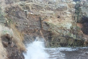
Actively eroding structural elements and buildings are visible in the cliffs below the Castle.
ShoreUPDATE October 2019
Mostly as described. The N-S aligned wall running south from the north end of the east range has partially collapsed around a former doorway. Structures in cliff below castle remain vulnerable to erosion and wave action
Location
351823.00
701190.00
27700
56.2008629
-2.7780724
Submitted photographs
Image
Date
Caption
User
25/10/2019
June 2018: Main structures, and walling visible in cliff face (Photo: Bill Lees)
training1
31/08/2015
Detail of eroding 'seagate' buildings in cliff below Newark Castle, looking E
training1
31/08/2015
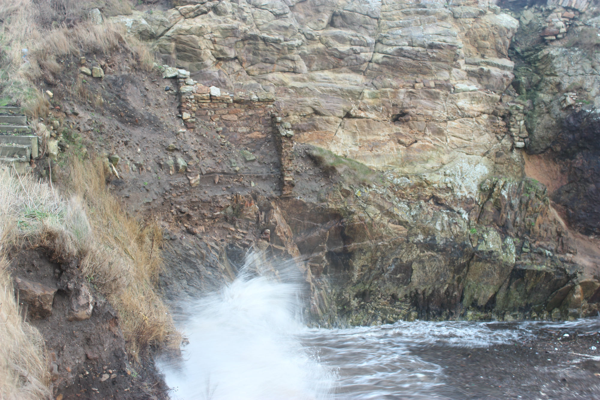
Eroding masonry buildings visible in cliff edge, looking E
training1
31/08/2015
Showing general coastal context of Newark Castle, looking E
training1
31/08/2015
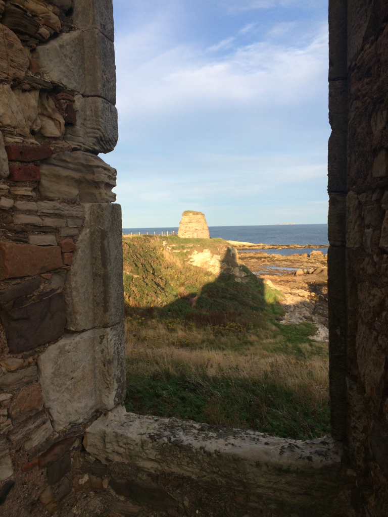
Newark Castle, looking towards doocot
marcyrockman
31/08/2015
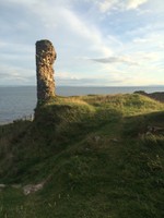
Newark Castle, structure at cliff edge
marcyrockman
Submitted updates
Update id
Date
User
3304
25/10/2019
training1
Description
ShoreUPDATE October 2019
Mostly as described. The N-S aligned wall running south from the north end of the east range has partially collapsed around a former doorway. Structures in cliff below castle remain vulnerable to erosion and wave action
Maintain priority 2 and regular update survey
2217
31/08/2015
marcyrockman
Tidal state
Low
Site located?
Yes
Proximity to coast edge
Coast edge
Coastally eroding?
active sea erosion
Threats
structural damage/decay
Visibility above ground
Highly visible (substantial remains)
Visibility in section
Not visible
Access
easily accessible - no restrictions; accessible on foot (footpath)
Local knowledge
is well known; is well visited
Description
The remains of Newark Castle stand on a small promontory running into the sea. The main buildings stand on the summit of the promontory to the E with remains of an enclosing wall to the S and on the W along the cliff.
The earliest work is in the three most southerly vaulted cellars of the E range. These have been altered and give no indication of date. In the second period, early 16th century, the block was extended N and terminated at the NE angle in a circular tower, with an entrance gate facing N in its W side. In the third period, late 16th century, a new house was built on the second period ground floor, extending from the cellars to the wall of the tower and having a stair tower towards the courtyard. Late in the 16th century, the cellarage was altered and buildings at the S end of the courtyard, as well as those on the lower level, erected. In the fourth period, later 17th century, a storey was added to the 16th c house, and an upper storey to the tower. The courtyard was divided by a cross wall running N along the W cliff to meet the main outer wall. Other buildings, now represented by fragments of vaulted cellars, lay at a lower level towards the NW, access between the two parts being maintained by a newel stair, still traceable. At the lower level there was probably a water gate. RCAHMS 1933, visited 1927.
Generally as described and planned, although the N tower has partially collapsed and the walling on the W has been eroded by the sea. Visited by OS (DWR) 30 May 1974.
NO 518 012 Newark Castle sits on a promontory on the N side of the Firth of Forth, 1km W of St Monans. It probably dates from the 15th century and originally comprised ranges of buildings set around a courtyard. In the 16th century, the E range was extended northwards and a circular tower built onto it. Later that century, the upper parts of the N end of the E range and the tower were rebuilt and some of the ground-floor chambers altered, the northernmost one becoming a kitchen. In the late 17th century, the 16th-century house was heightened and Dutch gables added to it. Some parts of the castle were still occupied well into the 19th century when the tower walls were cut back to provide additional living space. This action contributed to the collapse of the N wall of the tower early in the 20th century, whilst coastal erosion has resulted in the loss of other buildings, including the entire W side of the castle. An archaeological evaluation was undertaken in advance of a proposed programme of restoration of the N end of the E range and its round tower. The principal areas of excavation were: the interior of the round tower and its entrance passage; the kitchen and its fireplace; the first-floor hall; and four trenches against the castle walls.
The tower. The remains of the tower stood five storeys above ground level, although excavation also uncovered a hitherto unsuspected basement. The tower measured 7.5m in diameter over walls 2.2m thick at their base, but reduced over most of the building's height. Piercing the E and W walls of the basement were embrasures terminating in circular gun-loops which had probably opened onto a ditch. At some stage the ditch had been backfilled with at least 5m of rubble and soil. The basement floor was bedrock, into which a square feature had been cut - perhaps a well - which was not excavated. From ground level upwards, the tower walls have been reduced and alterations made to many of the mural features, such as windows and gun-loops.
The kitchen. The kitchen was formed when a large fireplace was inserted into the end of the northernmost undercroft of the E range. Most of the floor of this chamber comprised bedrock although some crude paving had been added where there were undulations in the rock. Cutting the bedrock was a narrow channel leading to a slop drain, set below a window in the E wall.
First-floor hall. This room, probably a hall during the later phases of occupation, lay directly over the kitchen and measured 6.2m N-S by 5m wide internally. Turf and debris overlay a deposit of sand, presumably the setting for floor tiles or flags, although no trace of either remained. There were two fireplaces in the hall, one directly over the kitchen fireplace, and another much smaller one in the S wall.
Trenches outside the castle. Four trenches were excavated against the castle walls, primarily to determine the depths of their foundations. This objective proved difficult to achieve for several reasons, although some interesting features were nevertheless uncovered. Trenches were opened against the two main doorways into the E range, one of which gave access to the passage leading to the tower, the other to the kitchen and a turnpike stair (now demolished) which led to the first-floor hall. In both trenches, large sandstone flags were overlain by a secondary surface of hard-packed gravel. In a trench outside the E range a relieving arch was uncovered near the base of the E wall, over 2m below present ground level. Also in this trench were the only artefacts pre-dating the late 19th century - sherds of probable 17th-century pottery, some of it French.
Sponsor: Nola Crewe.
J Lewis 2002
ShoreUPDATE 31/08/2015
Actively eroding structural elements and buildings are visible in the cliffs below the Castle.
Reassign priority 2 on the basis of structural elements in the cliffs below the castle being damaged by wave action.
Detailed photographic survey of cliff face followed up by regular photographic survey.
Comments
This is a prominent and well-visited heritage asset on the popular Fife Coastal Path. A management plan is urgently required.